


Monetier

Arthur Robin
User
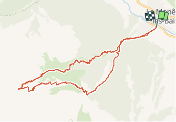

Length
12.4 km

Max alt
2737 m

Uphill gradient
1260 m
Km-Effort
29 km

Min alt
1467 m

Downhill gradient
1260 m
Boucle
Yes
Creation date :
2021-02-24 07:19:50.141
Updated on :
2021-02-24 14:04:37.602
6h42
Difficulty : Difficult

FREE GPS app for hiking
 SityTrail
IGN / Geographical institutes
SityTrail Plus
The world is yours!
About
Trail Touring skiing of 12.4 km to be discovered at Provence-Alpes-Côte d'Azur, Hautes-Alpes, Le Monêtier-les-Bains. This trail is proposed by Arthur Robin.
Positioning
Country:
France
Region :
Provence-Alpes-Côte d'Azur
Department/Province :
Hautes-Alpes
Municipality :
Le Monêtier-les-Bains
Location:
Unknown
Start:(Dec)
Start:(UTM)
303346 ; 4983021 (32T) N.
Comments